Log in
All resources
Create a design
4,838 Free Artworks of Maps Of France
bibliothèque nationale de france
maps by pieter van der keere
maps by nicolas sanson
tresor des cartes geographiques (1659)
maps with cartouches
maps of spain by tomas lopez
maps by tomas lopez
maps by juan lopez
beschreibung der städt der welt - braun & hogenberg - btv1b52512111k
maps by willem and johannes blaeu
synopsis universae philologiae
1741 maps of europe
maps by pieter van der keere
1610s maps of belgium
18th-century maps of barbados
1780 maps of the caribbean
maps of spain by tomas lopez
1770 maps of spain
maps of tangier by braun & hogenberg
maps of safi by braun & hogenberg
beschreibung der städt der welt - braun & hogenberg - btv1b52512111k
maps of 's-hertogenbosch by braun & hogenberg
hendrik van langren map of south asia
1600 maps of asia
maps by pieter van der keere
old maps of basel
beschreibung der städt der welt - braun & hogenberg - btv1b52512111k
panoramic maps of seville by braun & hogenberg
maps of france by hendrik hondius
old maps of cambrai
1891 maps of austria-hungary
maps from gallica
beschreibung der städt der welt - braun & hogenberg - btv1b52512111k
maps of tunis by braun & hogenberg
beschreibung der städt der welt - braun & hogenberg - btv1b52512111k
maps of münster (westfalen) by braun & hogenberg
18th-century maps of bretagne
robert cordier (engraver)
cartes de franz schrader
old maps of algeria
maps of goa by braun & hogenberg
maps of diu by braun & hogenberg
1600s maps of belgium
old maps of flanders
maps by pieter van der keere
willem barentsz
maps by pieter van der keere
old maps of utrecht
maps of paris from paris musées
maps of paris by jean lattré
maps of paris from bibliothèque nationale de france
plan de roussel
maps of mountains of cantal
cartes de franz schrader
maps by willem and johannes blaeu
1660s maps of france
advertising posters for the chemins de fer de paris à lyon et à la méditerranée
hugo d’alesi
1770s maps of the world
maps by tomas lopez
17th-century maps of xaintonge
maps by jodocus hondius
maps of spain by tomas lopez
maps of zamora
bibliothèque nationale de france
propaganda map
maps by thomas kitchin
1750s maps of germany
18th-century maps of the canary islands
maps of spain by tomas lopez
maps from géographie illustrée de la france et de ses colonies
19th-century maps of alpes-maritimes
bibliothèque nationale de france
propaganda map
18th-century maps of the canary islands
maps of spain by tomas lopez
maps by thomas kitchin
1750s maps of germany
maps by pieter van der keere
old maps of north brabant
le royaume de france distingué by guillaume sanson
1724 maps of france
novus atlas sinensis
old maps of shanxi
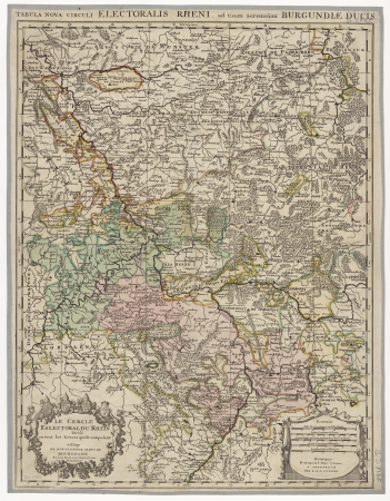
map of the circle of the rhineland by sanson
1700s maps of rhineland-palatinate
maps from géographie illustrée de la france et de ses colonies
maps of loiret
ambroise tardieu
j. p. besançon
sanson maps of north america
maps by nicolas sanson
sanson maps of north america
maps by nicolas sanson
sanson maps of north america
maps by nicolas sanson
beschreibung der städt der welt - braun & hogenberg - btv1b52512111k
maps of trier by braun & hogenberg
sanson maps of north america
maps by nicolas sanson
cartes de franz schrader
1894 maps of france
maps of alsace by guillaume sanson
robert cordier (engraver)
lutetia parisiorum urbs, toto orbe celeberrima notissimaque caput regni franciæ by sebastian münster
maps of paris from bibliothèque nationale de france
lutetia parisiorum urbs, toto orbe celeberrima notissimaque caput regni franciæ by sebastian münster
maps of paris from bibliothèque nationale de france
atlas - voyage pittoresque à l'île-de-france, au cap de bonne-espérance et à l'île de ténériffe (1812) by milbert
maps from the mechanical curator collection
tresor des cartes geographiques (1659)
17th-century maps of silesia
maps of cities in venezuela
maps by juan lopez
maps of erfurt by braun & hogenberg
maps of jena by braun & hogenberg
ptolemy's 3rd european map
bologna ptolemy
le royaume de france distingué by guillaume sanson
maps by nicolas sanson
19th-century maps of greece
pierre françois tardieu
atlas maior, vol 7 (france i) - joan blaeu, 1667 - bl 114.h(star).7
1667 maps
1660s maps of france
old maps of nevers
maps by tomas lopez
1785 maps of africa
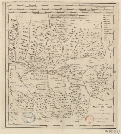
maps of the kingdom of jaén (crown of castile)
maps of spain by tomas lopez
maps showing history of the early middle ages
charles the bald
maps of duisburg by braun & hogenberg
maps of emmerich by braun & hogenberg
maps of the kingdom of córdoba (crown of castile)
maps of spain by tomas lopez
robert cordier (engraver)
1789 maps of france
robert cordier (engraver)
1789 maps of france
maps of paris from bibliothèque nationale de france
map of paris by claes jansz. visscher
maps of paris from the david rumsey historical map collection
maps of paris by caspar merian
maps from géographie illustrée de la france et de ses colonies
19th-century maps of calvados
maps of mombasa by braun & hogenberg
maps of cefala by braun & hogenberg
sanson maps of north america
maps by nicolas sanson
1660s maps of france
maps of le mans
1914 in present-day nouvelle-aquitaine
20th-century photographs of landes
maps by pieter van der keere
maps by abraham ortelius
17th-century maps of mecklenburg-vorpommern
johann lauremberg
old maps of hindeloopen
baroque
18th-century maps of western europe
1754 maps of europe
jodocus hondius ii, nova totius terrarum orbis geographica ac hydrographica tabula, 1636
map
turgot map of paris – derivative files
château de la tournelle (paris)
1572 maps of africa
1570s maps of egypt
map of the upper rhenian circle by sanson
maps by nicolas sanson
tresor des cartes geographiques (1659)
1650s maps of eastern europe
tresor des cartes geographiques (1659)
17th-century maps of siberia
tresor des cartes geographiques (1659)
old maps of tunis
maps by pieter van der keere
ships on maps
bibliothèque nationale de france
1698 map of evesché de meaux
1780s maps of cuba
maps by juan lopez
le royaume de france distingué by guillaume sanson
1724 maps of france
1782 maps of the caribbean
maps by juan lopez
tresor des cartes geographiques (1659)
1650s maps of the tsardom of russia
atlas - voyage pittoresque à l'île-de-france, au cap de bonne-espérance et à l'île de ténériffe (1812) by milbert
maps from the mechanical curator collection
1771 maps of africa
maps by tomas lopez
atlas minor gerardi mercatoris (1621, maps)
maps of china by mercator-hondius
maps by hendrik hondius the younger
maps from gallica
tresor des cartes geographiques (1659)
maps facing east
tresor des cartes geographiques (1659)
1650s maps of the world
1660s maps of france
maps of lyonnais
maps by tomas lopez
1785 maps
1780s maps of the caribbean
maps by tomas lopez
1780s maps of the caribbean
maps by tomas lopez
1780s maps of the caribbean
maps by juan lopez
801 - 900 of 4,838
Next page
/ 49


![Map of Paris ([Reprod. in facsim.]) / by Roussel, engineer in 1700, 1730](https://cdn.creazilla.com/illustrations/10001522196/map-of-paris-reprod-in-facsim-by-roussel-engineer-in-1700-1730-sm.webp)


![Treasure of geographical maps of the main states of the universe [...], 1659](https://cdn.creazilla.com/illustrations/10000859170/treasure-of-geographical-maps-of-the-main-states-of-the-universe-1659-md.jpg)


![Treasure of geographical maps of the main states of the universe [...], 1659](https://cdn.creazilla.com/illustrations/10000594631/treasure-of-geographical-maps-of-the-main-states-of-the-universe-1659-md.jpg)
![Treasure of geographical maps of the main states of the universe [...], 1659](https://cdn.creazilla.com/illustrations/10001176343/treasure-of-geographical-maps-of-the-main-states-of-the-universe-1659-md.jpg)
![Treasure of geographical maps of the main states of the universe [...], 1659](https://cdn.creazilla.com/illustrations/10000832962/treasure-of-geographical-maps-of-the-main-states-of-the-universe-1659-md.jpg)


![Treasure of geographical maps of the main states of the universe [...], 1659](https://cdn.creazilla.com/illustrations/10000302483/treasure-of-geographical-maps-of-the-main-states-of-the-universe-1659-md.jpg)


![Treasure of geographical maps of the main states of the universe [...], 1659](https://cdn.creazilla.com/illustrations/10000441201/treasure-of-geographical-maps-of-the-main-states-of-the-universe-1659-md.jpg)
![Treasure of geographical maps of the main states of the universe [...], 1659](https://cdn.creazilla.com/illustrations/10001492378/treasure-of-geographical-maps-of-the-main-states-of-the-universe-1659-md.jpg)


